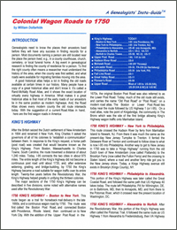
“Genealogists need to know the places their ancestors lived before they will have any success in finding records for a person. Most documents naming a person are still located near the place the person lived, e.g. In a county courthouse, church, cemetery, or local funeral home. A big event in genealogical research is finding the county of residence for a person. To find the right county often means a researcher must understand the history of the area, when the county was first settled, and what roads were available for migrating families moving into the area.”
Not so surprising, many of today’s highways and byways follow the same path they did when first established, often as little more than a horse trail or wagon road. In Colonial Wagon Roads to 1750, author William Dollarhide provides a brief history of colonial roads that still exist today. This information is nicely packaged in the first Genealogists’ Insta-Guide™ from Family Root Publishing.
This new Insta-Guide begins with a brief introduction along nice a table showing the colonial roads covered in this guide alongside their current highway designations. The bulk of the guide is broken into two sections. The first is the King’s Highway, broken into the five major section as it existed in 1750. The second group of roads comes under the banner Scots-Irish Influence on Road Building in Colonial America. There is another brief background followed by information on nine more major colonial roads. The guide is completed with a nearly full page map of these 1750 Colonial roads and a section for print and online references.
When talking with Leland Meitzler from Family Roots Publishing about this new guide, he mentioned the greatest difficulty Dollarhide had in preparing this guide was finding additional resources to add to the guide that didn’t already just quote himself. I guess that is the type of problem one may encounter when they are the nation’s preemptive expert on early migration routes. Readers will only get the best from this guide.
Like other quick sheets, and “at a glance” guides, the new Genealogists’ Insta-Guide series features four-page, laminated, colored guides which fit nicely into three-ringed binders and portfolios. By this design, these guides are easy to take along for sharing or going to the library for research; not to mention, they are easy to store. The Insta-Guide comes pre-punched for three-ringed insertion.
Here’s the real kicker for this new guide series, you can order the Insta-Guide as a printed piece or as a downloadable .pdf file for your computer; plus, supporting tablets and smart phones — as long as your device supports .pdf [Acrobat] files.
Contents
Introduction
Highway Table
King’s Highway
- 1750 King’s Highway – Boston to New York
- 1750 King’s Highway – New York to Philadelphia
- 1750 King’s Highway – Philadelphia to Alexandria
- 1750 King’s Highway – Alexandria to Norfolk
- 1750 King’s Highway – Norfolk to Charles Town
Scots-Irish Influence on Road Building in Colonial America
- Upper Post Road
- Hudson River Road
- Mohawk Road
- Lancaster Road
- Fall Line Road
- Great Valley Road
- Philadelphia Road
- Pioneer’s Road
- Upper Road
Map of 1750 Colonial Wagon Roads
Print References
Online References
Order Colonial Wagon Roads to 1750 from Family Roots Publishing; Price: $7.95.
Or, click here to order the electronic (.pdf) version of Colonial Wagon Roads to 1750; Price: $3.99.
