The following excerpt is from an article Posted July 27, 2016 at CityLab.com:

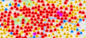
With over 150,000 pictures now mapped across the city, a new digital photo archive of the city of London is so rich in content it’s almost too much to cope with.
Launched last week, Collage, The London Picture Map allows you to trace London’s visual history street by street. Supported by the City of London Corporation, it’s the result of two full years of digitizing and mapping images from the London Metropolitan Archive and the Guildhall Art Gallery, which together possess the largest collection of London images in the world.
This huge task has now made reimagining old London easier than ever. Simply choose a location across the city and a few clicks will lead you directly to tens of thousands of photos, paintings, drawings and historic posters. It’s the ideal visual counterpart to an ancient city where, even in recently built areas, you can often feel like you’re treading on ghosts. Think of the London Picture Map as a dream chest opening up views to not just what once was, but to what could have been.
Thanks to ResearchBuzz for the Heads-Up.