The following article is by my friend Bill Dollarhide, taken from his book, Wyoming Censuses & Substitute Name Lists, 1850-2015
 Prologue: In 1869, Wyoming became the first territory to grant the right to vote to women. But there were other firsts in Wyoming, e.g., the first National Park (Yellowstone, 1872); the first National Forest (Shoshone, 1891); and the first National Monument (Devils Tower, 1906). Wyoming started as a place people tried to cross as quickly as possible, avoiding the local natives, who seemed to resent all those white people invading their territory. But after the initial interest in gathering furs from Wyoming’s mountains and streams, the interest turned to taking advantage of some of America’s best grazing land, well watered, and wide open for the taking.
1742. The first non-Indian to visit the area of Wyoming was probably Francois Louis Vérendrye, a French Canadian trapper and fur trader from the Red River Settlement of the Dakota Country.
1807. John Colter, recent member of the Lewis and Clark expedition, now a mountain man and explorer, was the first to describe a place where “hot water shoots straight into the air, the earth bubbles as if it were boiling, and almost extinct geysers thunder as if possessed by angry spirits.” He referred to the area in his written report as Colter’s Hell. Most easterners believed he was lying or exaggerating – it was hard to believe such a place could really exist. Colter’s Hell is now called Yellowstone National Park.
1811. Wilson Hunt led a party of “Astorians,” an organized expedition for John Jacob Astor’s American Fur Company. The Astorians left St. Louis, following the same path used and recorded by Lewis and Clark, passing through present Wyoming on their way to Astoria, at the mouth of the Columbia River.
1813. Displaced by the War of 1812, the Astorians returned to St. Louis by way of an easier Wyoming grade through the Rocky Mountains, later known as South Pass. The Astorians built the first known cabin on the North Platte River at Bessemer Bend, a few miles southwest of present Casper, Wyoming. The South Pass route was to become the primary crossing point of the Continental Divide for many thousands of covered wagons traveling the Oregon Trail over the next 60 years.
1822. General William Ashley placed an ad in a St. Louis newspaper to recruit able-bodied men for his new fur-trading enterprise. There was no shortage of willing young men. Ashley would not build a chain of forts to manage his fur trading operation. Instead, he sent his men out alone and made arrangements to meet them all at a central place a year later. At the predetermined time, Ashley would load up his wagons with supplies and head off to meet his men.
1824. William Ashley’s men rediscovered South Pass. The Rocky Mountain Fur Company trappers and traders, including Indians and Mountain Men, begin holding their annual meetings along the Green River of present Wyoming.
1825. William Ashley’s wagons were the first vehicles to penetrate into the west, blazing a wagon road for the Oregon Trail settlers who would follow twenty years later. When Ashley finally reached his men each year, it was cause for celebration – a wild party they called the Rendezvous.
1832. Capt. B. L. E. Bonneville took wagons through South Pass, then built Fort Bonneville (the Green River Rendezvous) near present Daniel, Wyoming.
1834. Fort Laramie, a private trading post, was the first permanent settlement in Wyoming, established by William Sublette and Robert Campbell, successors to William Ashley’s Rocky Mountain Fur Company.
1836. Narcissa Whitman, wife of Dr. Marcus Whitman; and Eliza Spalding, wife of Rev. Henry H. Spalding; were the first white women to pass over the Oregon Trail to the Far West.
1837. A rendezvous on the Green River of Wyoming was attended by more than 2,000 Mountain Men, Trappers, Fur Traders, and Indians. But, styles had already begun to change and top money was not received for the furs.
1842. The great migration began on the Oregon Trail. Also in this year, gold was discovered in the South Pass district, but the major gold rush would be delayed by the coming Civil War and would not start in earnest until the late 1860s.
1843. Fort Bridger, the second permanent settlement in Wyoming was established by Jim Bridger and Louis Vasquez.
1846. The Mormon migration to Utah began. In 1847, Mormon Ferry was established on the North Platte River in present Wyoming.
1849. U.S. Government purchased Ft. Laramie, turning it into a military post. Many of the great treaties with the Indians were concluded here over the next thirty years.
1850. Present Wyoming was now part of Utah and Oregon Territories west of the Continental Divide; and in “Unorganized Territory,” east of the divide. In the 1850 federal census, the only population in present Wyoming was that of Fort Bridger, taken as the “Green River Precinct” of Weber County, Utah Territory. The Federal Census was taken in Utah Territory with a census day of April 1, 1851.
1852. This was the peak year for emigration on the Oregon Trail. Over 55,000 people passed through Wyoming en route to Oregon or California.
1853. Washington Territory was created, taken from the area of Oregon Territory. The southwest corner of present Wyoming (west of the Continental Divide) was now part of Washington and Utah Territories; the area east of the divide was in “Unorganized Territory.”
1853. Fort Supply, an agricultural settlement in present Wyoming (a bit south of Fort Bridger) was established as a re-supply station by the Mormons.
1854. Nebraska Territory was established, extending from the Missouri River to the Continental Divide. The area of modern Wyoming was now within Nebraska Territory east of the Continental Divide; the area west of the divide, within Washington and Utah Territories.
1860. April. The Pony Express was started, a mail route from St. Joseph, MO to Sacramento, CA which followed the same path as the original Oregon-California Trail through present Wyoming.
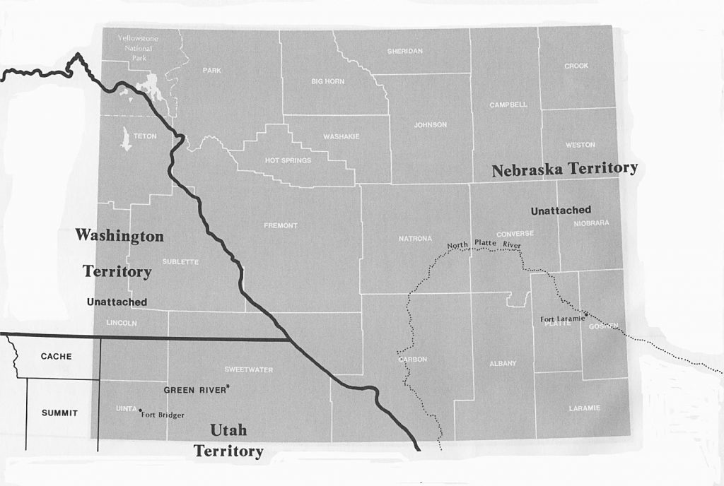
1860. June. Federal Census. This map shows the area of Wyoming as part of Nebraska, Utah, and Washington Territories at the time of the 1860 federal census. The 23 current counties of Wyoming are shown in white. The 1860 federal census population schedules are extant for Fort Bridger in Utah Territory and Fort Laramie in Nebraska Territory. * Map Note: Green River County, Utah Territory was never organized and ceased to exist upon the creation of Wyoming Territory in 1868. Map Source: Page 387, Map Guide to the U.S. Federal Censuses, 1790-1920,, by William Thorndale and William Dollarhide.
1861. Dakota Territory was created by Congress. Present Wyoming east of the Continental Divide was now part of Dakota and Nebraska Territories; and Washington and Utah Territories west of the divide.
1861. October. The first transcontinental telegraph was completed. The transmission lines followed the same route as the Oregon Trail into Wyoming to Fort Hall, then the California Trail into Utah, Nevada, and California, terminating in Sacramento. A month later, the Pony Express was discontinued.
1862. The Overland Stage Line changed its route from the Oregon Trail to the new Overland Trail. From Denver, the Overland Trail went north to Ft. Collins via what is now Interstate 25, then from Ft. Collins into Wyoming to the Laramie River via what is now U.S. Highway 287; then west to Ft. Bridger along the same general route of today’s Interstate 80.
1863. Idaho Territory was created by Congress, with an area that included all of present Idaho, Montana, and Wyoming.
1863. Bozeman Trail established. The portion of the route from present Cheyenne, Wyoming to Billings, Montana followed the same general path as Interstate 25; and from Billings to Bozeman, Montana via what is now Interstate 90.
1866. Cattleman Nelson Story drove the first herd of cattle through present Wyoming, going north to Montana, essentially along the route of the Bozeman Trail. (This cattle drive was the historical setting for Larry McMurtry’s Lonesome Dove).
1867. The Union Pacific Railroad entered present Wyoming, still part of Dakota Territory. Railroad workers founded the city of Cheyenne in this year; and Laramie County was created by the Dakota Territory Legislature.
1868. July 25th. Wyoming Territory was created by Congress with the same boundaries as the present state. Cheyenne was named the territorial capital.
1869. A territorial census was taken for Wyoming Territory. This is the only census that survives for all Wyoming counties.
– Also in this year, John A. Campbell, first territorial governor, signed the Female Suffrage Bill giving women the right to vote. Wyoming was the first territory or state in the United States to do so.
1870. June. Federal census. Wyoming Territory’s population was at 9,118.
1872. Yellowstone National Park was created, the first national park in America. A northern strip of the park is in Montana; a western strip is in Idaho; but most of the park is within Wyoming.
1880. June. Federal census. Wyoming’s population was at 20,789.
1889. The state constitution submitted to Congress for admission as a state included an article that provided: “Elections shall be open, free and equal, and no power, civil or military, shall at any time interfere to prevent an untrammeled exercise of the right of suffrage,” allowing Wyoming to become the first state to extend voting rights to women.
1890. June. Federal Census. Wyoming Territory’s population was at 62,555.
1890. July 10th . Wyoming was admitted into the Union as the 44th state with Cheyenne as the state capital.
About Wyoming’s Censuses
– The 1850 federal census was the first to include inhabitants of the area of present Wyoming. Fort Bridger was enumerated as the “Green River Precinct” of Weber County, Utah Territory. The 1850 Federal Census was taken in Utah Territory with a census day of April 1, 1851.
– The 1860 federal census included Fort Bridger, Green River County, Utah Territory; and Fort Laramie in Nebraska Territory.
– Federal censuses for Wyoming are complete for all counties, 1870-1940 (with the exception of the 1890, lost for all states).
– There were several territorial/state censuses taken 1869 to 1905, but only the 1869 (entire territory) and 1885 (Ft. Laramie only), survive with names. The others have statistical reports only. There are no surviving state censuses for the State of Wyoming .
Further Reading:
Wyoming Censuses & Substitute Name Lists, 1850-2015 (Printed Book), Softbound, 77 pages, Item FR0309.
Wyoming Censuses & Substitute Name Lists, 1850-2015 (PDF eBook), 77 pages, Item FR0310.
Online Wyoming Censuses & Substitutes: A Genealogists’ Insta-Guide™ (Laminated), 4 pages, Item FR0413.
Online Wyoming Censuses & Substitutes: A Genealogists’ Insta-Guide™ (PDF eBook), 4 pages, Item FR0414.
